cChargeLondon.co.uk
Coverage of the London Congestion Charge
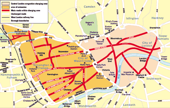
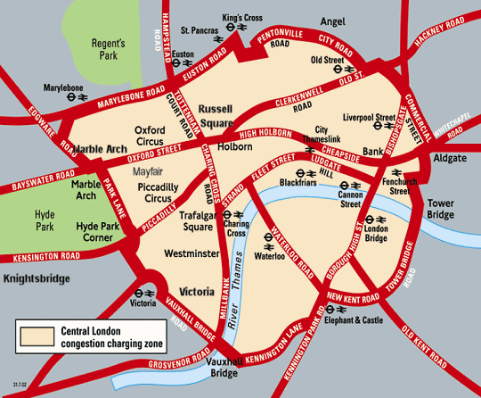
London Congestion Charge's Original & Current Boundary Zone
The original and current boundary of the zone is sometimes referred to as the London Inner Ring Road. Starting at the northernmost point and moving clockwise, the major roads defining the boundary are Pentonville Road, City Road, Old Street, Commercial Street, Mansell Street, Tower Bridge Road, New Kent Road, Elephant and Castle, Vauxhall Bridge Road, Park Lane, Edgware Road, Marylebone Road and Euston Road (other roads fill the small gaps between these roads). The zone therefore includes the whole of the City of London, the city's financial district, and the West End, the city's primary commercial and entertainment centre. There are also 136,000 residents living within the zone (of a total population of around 7,000,000 in Greater London), though the zone is primarily thought of (and zoned) as commercial rather than residential. There is little heavy industry within the zone. Signs have been erected and symbols painted on the road to help drivers define the congestion charge area.
London Congestion Charge and the OLD Western Extension
The boundary of the enlarged zone, began at the northern end of Vauxhall Bridge and (travelling in a clockwise direction) heads along the northern bank of the River Thames as Grosvenor Road, the Chelsea Embankment and Cheyne Walk. From here, it heads north, along the eastern edges of the Kensington and Earl's Court one-way systems (classified as part of the A3220), encompassing Edith Grove, Redcliffe Gardens, Earl's Court Road, Pembroke Road, Warwick Gardens and part of the Addison Road, before continuing to the A40 Westway as the Holland Road and the West Cross Route.
The boundary then included parts of North Kensington, but the actual boundary was defined by the West London Line railway track, which runs between Latimer Road (inside the zone) and Wood Lane (outside the zone), until Scrubs Lane, before turning east, following the Great Western Main Line out of Paddington towards Ladbroke Grove. Here, the boundary followed the Grand Union Canal and rejoined the existing zone at Edgware Road after skirting Paddington, by way of the Bishop's Bridge Road, Eastbourne Terrace, Praed Street and Sussex Gardens.
TfL had defined some free through routes, where drivers did not have to pay the charge. The main route was defined by the western boundary of the original zone Vauxhall Bridge Road, Grosvenor Place, Park Lane and Edgware Road, with some additions around Victoria. The Westway was the other exempt route.